BETA
11.08.2026
Morning update for the solar eclipse on 12 August
A low-pressure system is expected to approach southern Iceland on Wednesday. The latest weather model runs place the centre of the low just south of the Reykjanes peninsula on Wednesday afternoon, with its associated fronts moving across most of the country. The low is then expected to move eastwards along the south coast.
Precipitation will mainly affect southern Iceland, while the Breiðafjörður region and the Westfjords should see less precipitation until the evening, when the fronts are expected to move across the area. These regions are therefore most likely to see breaks in the cloud around the time of the eclipse. Northern Iceland is also expected to remain mostly dry well into the day. More detailed forecasts for each forecast area in western Iceland, with particular regard to the eclipse, are provided below.
Most models now place the low in a similar position, suggesting that its location is becoming more certain. However, there is still some uncertainty about the extent of the frontal system, including its timing, intensity and how far north it will extend into Faxaflói bay. This will have a major bearing on whether, and how clearly, the eclipse can be seen, particularly in northwestern Iceland.
The Icelandic Meteorological Office’s high-resolution models distinguish between three cloud layers: high, middle and low cloud. High cloud has relatively little effect on viewing the eclipse, as sunlight can pass through it fairly easily. Middle cloud is less transparent, although it does not necessarily prevent the eclipse from being seen. If low cloud covers an area, however, there is little chance of seeing either the Sun or the eclipse.
The total cloud-cover forecast indicates that the country will be almost entirely overcast at 18:00, as shown in the green panel. However, the low-cloud forecast shows some breaks over parts of western Iceland and the Westfjords. The middle- and high-cloud forecasts show breaks in broadly similar areas, although not in exactly the same locations. The upper image is from the latest run of the IG high-resolution model, while the lower image shows the DINI high-resolution model. The models do not fully agree, so the precise location of any breaks in the cloud remains uncertain.
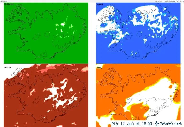
IG high-resolution model, latest run initialised at 09:00 UTC on 11 August.
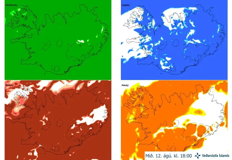
DINI high-resolution model, latest run initialised at 09:00 UTC on 11 August.
Cloud-cover forecasts are among the most difficult model products to calculate because the underlying physical processes are highly complex. Small breaks such as these should therefore be treated with caution. The forecasts indicate that breaks could form in the cloud cover over the area, but their precise locations cannot be predicted.
The forecast for the whole country on Wednesday is as follows:
East or northeast winds of 3 to 10 m/s, somewhat stronger along the south coast. Cloudy with intermittent rain in many areas, but somewhat less precipitation in the northwest by evening. Temperatures of 8 to 18°C, coolest along the north and east coasts.
The precipitation forecast charts below, from the Icelandic Meteorological Office’s IG and DINI high-resolution models, are valid at 18:00 on Wednesday. They show in greater detail where rain is expected to fall and the extent of the precipitation. Once again, the charts demonstrate the uncertainty surrounding its precise location. The best chance of breaks in the cloud remains around Breiðafjörður, particularly in the Westfjords.
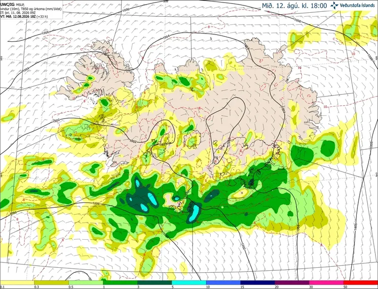
Precipitation and wind in the IG high-resolution model, latest run initialised at 09:00 UTC on 11 August.
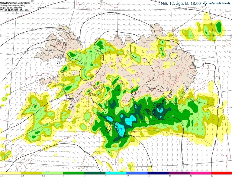
Precipitation and wind in the DINI high-resolution model, latest run initialised at 09:00 UTC on 11 August.
Weather outlook along the path of totality
Capital region
Rather light easterly or northeasterly winds, cloudy conditions and showers. Rain will become more persistent for a time towards evening before easing again. There is little chance of breaks forming in the cloud around the time of the eclipse.
Reykjanes peninsula
Conditions will be similar to those in the capital region, with northeasterly winds and showers. Rain will become more persistent for a time towards evening before easing. There is little chance of breaks forming in the cloud.
Snæfellsnes
Easterly winds and generally dry conditions until after midday, followed by intermittent rain or showers. It will probably be cloudy, but as the frontal system appears to weaken around the time of maximum eclipse, there is a chance that the low- and middle-level cloud may break up locally around Breiðafjörður towards evening.
Westfjords
Rather light northeasterly winds and mostly cloudy conditions. It will remain dry for most of the day, with isolated showers towards evening and increasing precipitation late in the evening. High cloud is expected, with little low cloud apart from some in western areas. Breaks may form in the middle-level cloud, particularly in the northwest.