BETA
Final solar eclipse forecast: Best chance of seeing the Sun around Breiðafjörður and in the Westfjords
12.08.2026
Final solar eclipse forecast: Best chance of seeing the Sun around Breiðafjörður and in the Westfjords
The forecast was issued at 16:00, about 45 minutes before the solar eclipse begins and just under two hours before totality.
According to satellite imagery, the low-pressure system is now located just south of Reykjanes, and its associated fronts have reached Iceland. They are bringing heavy showers across southern Iceland, with some breaks between showers, although the cloud cover will not clear completely. With luck, gaps in the cloud cover may coincide with the eclipse. This also applies to the Reykjanes Peninsula, the Capital area and the Faxaflói area.
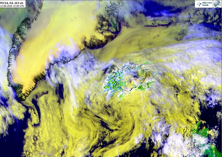
Satellite image from EUMETSAT’s MTG satellite at 15:00 on 12 August 2026. Radar reflectivity from the Icelandic Meteorological Office’s weather radars is overlaid on the image. Green and blue colours indicate precipitation. Image: EUMETSAT and the Icelandic Meteorological Office.
The low will then move eastwards along the south coast. Precipitation will continue to be mainly confined to southern Iceland, with less precipitation around Breiðafjörður and in the Westfjords. These areas still have the best chance of breaks developing in the low cloud around totality. During the partial phase, the greatest chance of seeing the Sun is around Tröllaskagi and Héraðsflói. More detailed weather forecasts for each forecast area in western Iceland, specifically for the eclipse, are provided below.
The Icelandic Meteorological Office’s models divide cloud cover into three layers: high, mid-level and low cloud. High cloud has little effect on views of the eclipse, as sunlight can pass through it relatively easily. For example, a halo around the Sun can be seen through high cloud. Mid-level cloud allows less sunlight through, but it may still be possible to enjoy the eclipse. If low cloud covers an area, however, the chances of seeing the Sun are small. Nevertheless, the eclipse will still be noticeable under such conditions.
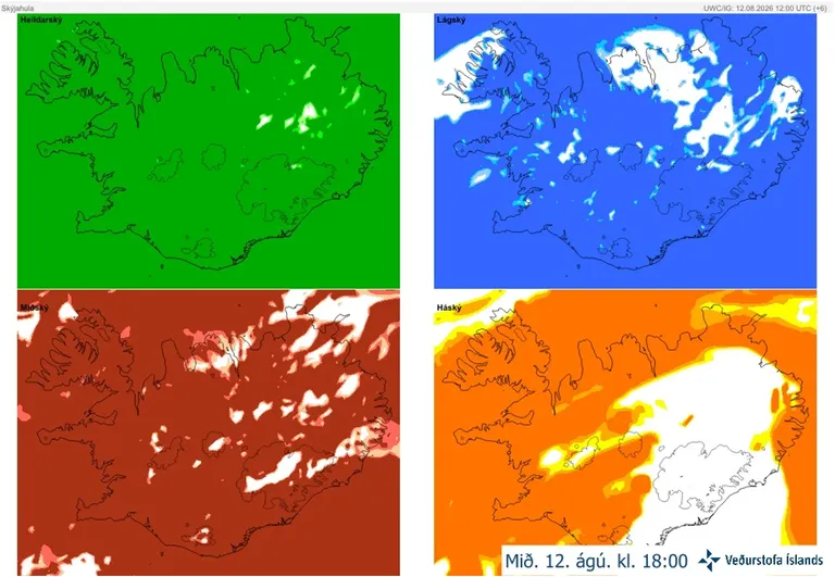
Cloud cover forecast from the IG high-resolution model. Latest model run from 12:00 on 12 August.
Cloud cover forecasts are among the most difficult forecast products to calculate because the physical processes involved are highly complex. Small gaps in the cloud cover shown by the models should therefore be treated with caution. The forecasts indicate areas where gaps may develop, but their precise locations cannot be determined.
Today’s forecast for Iceland is as follows:
Easterly winds of 5–13 m/s, strongest along the south coast. Rain or showers, but less precipitation across northern Iceland until later in the day. Temperatures of 10–20°C, warmest in the north.
The precipitation forecast map below is from the Icelandic Meteorological Office’s IG high-resolution model and is valid at 18:00 today. It shows where rain is forecast and the extent of the area affected. Once again, it illustrates how difficult it is to determine the precise location of the precipitation.
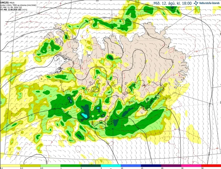
Precipitation and wind forecast from the IG high-resolution model. Latest model run from 12:00 on 12 August.
Weather outlook along the path of totality
Capital area
Light easterly or northeasterly winds, cloudy with showers. Gaps may develop between showers, allowing views of the eclipse, but the chances are not high.
Reykjanes Peninsula
Similar conditions to the Capital area, with northeasterly winds and heavy showers. There will be some breaks between showers, although the cloud cover is unlikely to clear completely. The chances of gaps developing in the cloud cover are not high.
Snæfellsnes
Easterly winds, cloudy with showers. As the front is likely to weaken around maximum eclipse, there is a chance that the low and mid-level cloud will break up in places.
Westfjords
Light northeasterly winds and isolated showers. High cloud is expected, with broken low cloud in western parts and possible gaps in the mid-level cloud, particularly in the northwest. There is a chance of seeing the eclipse in this area.