BETA
Heavy precipitation until Sunday in Northern part of Westfjords and in Strandir area
24.09.2026
Attention
Heavy precipitation until Sunday in Northern part of Westfjords and in Strandir area
- Significant precipitation is expected in the northern Westfjords and the Strandir region, continuing through Sunday and in Strandir through Monday.
- Temperatures will drop on Friday, and precipitation may fall as snow or sleet in mountainous areas.
- Very high accumulated precipitation may lead to increased runoff, rockfalls, and landslides that could disrupt transportation.
A low pressure system will move across Iceland today, and around midday rain is expected to begin with some intensity in the northern Westfjords and Strandir. Today, Thursday, precipitation is expected to fall as rain, including in the mountains. As the wind shifts to a northerly direction tomorrow, Friday, the forecast indicates a marked drop in temperature, and part of the precipitation, at least on mountain summits, is expected to fall as snow or sleet. Snowfall near the coast is considered unlikely.
There is uncertainty in the forecast regarding the form of precipitation and the exact track of the low pressure system across the country. Nevertheless, weather forecasts indicate that accumulated precipitation will be considerable in the affected areas. Much of the road network in the Westfjords and Strandir lies below steep slopes, and rapid mass movements such as rockfalls, debris slides, and soil slides may disrupt transportation. It cannot be ruled out that slope movements may occur shortly after the heaviest precipitation has ended, as large amounts of water will still remain within the hillsides.
The latest weather model runs indicate that precipitation will continue through Sunday, and in Strandir through Monday. Total accumulated precipitation during this period is therefore expected to be very high, particularly in glacierized and mountainous areas. Increased runoff in streams and rivers may also affect travel conditions.
The public is advised to monitor information published by the Icelandic Road and Coastal Administration (https://umferdin.is/) and to stay informed about weather forecasts and warnings issued by the Icelandic Meteorological Office (https://www.vedur.is/vidvaranir).
The Icelandic Meteorological Office welcomes reports of landslides and other mass movement events. Reports can be made by calling +354 522 6000 during office hours (https://www.vedur.is/um-vi/hafa-samband/) or by sending an email with relevant information to skriduvakt@vedur.is. When possible, please include photographs of the event, an accurate location, and the time when the event occurred or was first observed. Reports can also be submitted using this online form: https://ee-eu.kobotoolbox.org/ucSPnWaO
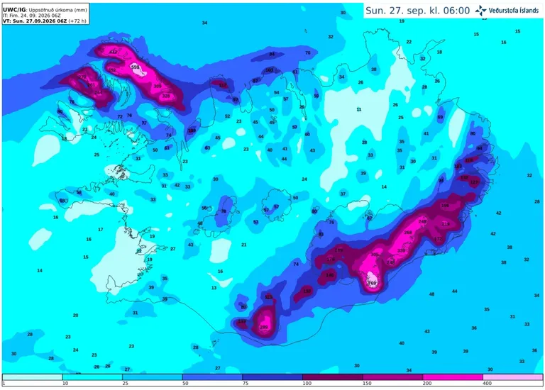
Accumulated precipitation over the next 72 hours, according to the IG weather model.