BETA
28.09.2026
Heavy rainfall this week
On Tuesday, Wednesday and Thursday, several low-pressure systems will pass over Iceland. They will bring heavy rainfall to South Iceland, Southeast Iceland and the southern Eastfjords. Significant rainfall is also expected in the northern Eastfjords, the Strandir region, the Central Highlands and Snæfellsnes.
In the Westfjords, particularly in Strandir, snowmelt will also contribute to rising water levels in rivers and streams. Following the rainfall in recent days, the soil is already saturated with water, and further rainfall over the coming days is expected to increase water pressure in slopes and soil layers.
Autumn low-pressure systems of this kind are not unusual at this time of year, but considerable rainfall and high rainfall intensity over short periods are expected. Under these conditions, ground movements such as rockfalls, debris flows and increased sediment transport in streams and rivers cannot be ruled out.
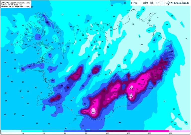
Accumulated precipitation over the next 72 hours, according to the IG weather model.
The Icelandic Meteorological Office’s Landslide Watch is closely monitoring the situation and will publish updated information, news and, when appropriate, special warnings as needed.
As roads often run beneath steep slopes, travellers are advised to exercise caution and follow information on the Icelandic Road and Coastal Administration’s website.
The public is encouraged to report landslides and rockfalls to the Landslide Watch. Reports can be sent by email to skriduvakt@vedur.is or submitted using the electronic reporting form for landslides and avalanches. Please provide the precise location and, if known, the time when the landslide or rockfall occurred. If the exact time is not known, it is sufficient to state when it was first observed. Please include photographs where possible. The Landslide Watch reviews the reports and attempts to verify them before they are entered into the Icelandic Meteorological Office’s landslide database.