BETA
28.09.2026
Landslide warnings last week
A large low-pressure system moved northwards across Iceland last week, bringing heavy rainfall to southern, eastern and northwestern parts of the country. As a result, yellow landslide warnings were issued for several landslide warning areas. The warnings were the first to be issued using the new landslide warning system. The Icelandic Meteorological Office also launched new webpages for landslide warnings. Both are intended to improve public information and make information about landslide hazards more accessible.
Landslide warnings are presented in a similar way to weather warnings, using yellow, orange and red warning levels. Iceland is divided into 15 landslide warning areas, and warnings are issued for areas where conditions indicate an increased likelihood of landslides.
On Thursday, 24 September, yellow landslide warnings were issued for South Iceland, Southeast Iceland, the southern Eastfjords, the Central Highlands, the Westfjords and Strandir. Considerable or heavy rainfall was forecast in these areas, with some areas expected to receive high rainfall intensity over short periods.
Both intense rainfall over short periods and prolonged rainfall can trigger landslides. However, it is not always easy to determine which factor is more important in a particular situation. The effects of rainfall depend, among other things, on soil moisture before the rainfall, geological conditions and topography.
During the warning period, reports of landslides were received from the Central Highlands. On 24 September, a landslide occurred near Landmannalaugar, temporarily blocking the route to and from the hut area. The incident illustrates how hazardous conditions can develop.
The following day, Friday 25 September, reports were received of rockfalls and landslides along Strandavegur, and the road had to be closed temporarily. Reports of rockfalls were also received from known rockfall locations in the northern Westfjords, including at Spillir in Súgandafjörður and in Ófæruhlíð in Önundarfjörður. Rockfalls were also observed at Gleiðarhjalli in Ísafjörður.
Heavy rainfall was recorded in the northern Westfjords while the warning was in effect. Northerly winds prevailed, and some of the precipitation fell as snow at higher elevations. This part of the precipitation therefore did not immediately reach the ground as rain, which may have reduced the landslide hazard at higher elevations while the rainfall was ongoing.
The Landslide Watch continues to monitor conditions and reports of landslides and rockfalls. Landslides can occur after the heaviest rainfall has passed. It can also take some time for landslides in remote and sparsely populated areas to be discovered. This is particularly relevant in the northern Westfjords, where the area is extensive and settlements are widely scattered.
Registered landslides can be viewed on the Icelandic Meteorological Office website. Reports received by the Landslide Watch are published there, providing an overview of the location and distribution of landslides across Iceland.
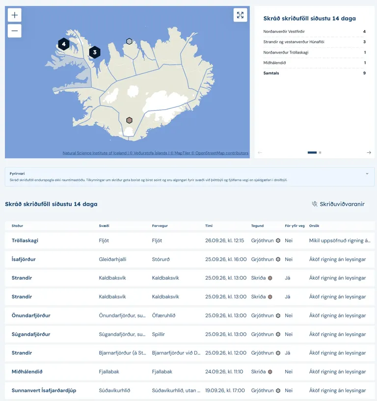
The website provides a map showing the locations of recorded landslides, along with a list containing information about each event.
The public is encouraged to report landslides and rockfalls to the Landslide Watch. Reports can be sent by email to skriduvakt@vedur.is or submitted using the electronic reporting form for landslides and avalanches.
Please provide the precise location and, if known, the time when the landslide or rockfall occurred. If the exact time is not known, it is sufficient to state when it was first observed. Please include photographs where possible. The Landslide Watch reviews the reports and attempts to verify them before they are entered into the Icelandic Meteorological Office’s landslide database.