BETA
23.09.2026
Attention
Significant rainfall on Thursday, 24 September
- Significant rainfall is expected in South Iceland, Southeast Iceland, the southern Eastfjords, the Westfjords and the Strandir region.
- Increased water levels and surface movements may occur following the rainfall, including rockfalls and debris flows.
- Caution is advised when travelling, particularly below steep slopes.
The weather forecast indicates significant rainfall in South Iceland, Southeast Iceland, the southern Eastfjords, the Westfjords and the Strandir region on Thursday, 24 September, continuing into Friday, 25 September.
Rainfall will begin in the southernmost parts of the country during the early hours of Thursday, including around Mýrdalsjökull, and will then spread northwards. The highest accumulated precipitation is forecast in the glacier regions, including Eyjafjallajökull, Mýrdalsjökull and Vatnajökull. The highest rainfall amounts are expected in Öræfi. Winds will be from the southeast and east.
Significant rainfall is expected through Thursday and into the early hours of Friday. Conditions will then become drier in the south, while precipitation will persist over Strandir, particularly in glacier and mountainous areas, and in the mountains of the northern Westfjords. Winds in the Westfjords will shift to northerly and northeasterly directions. Temperatures will drop, and snowfall is expected on mountain roads and in mountainous areas. Precipitation will continue in these areas into Saturday.
Accumulated precipitation is expected to be significant in the areas mentioned above. Weather model calculations also indicate periods of high precipitation intensity over short time intervals.
Following this rainfall, increased water levels are expected in rivers and streams, and channels that are normally dry may fill with water. Surface movements, including rockfalls, channelised debris flows and soil slides, may occur suddenly and with little warning. People are therefore advised not to stop below steep slopes and to exercise particular caution when travelling on the country's roads. No hazard from landslides and other avalanches is currently expected in populated areas.
People are advised to follow information from the Icelandic Road and Coastal Administration and to monitor the weather forecast and warnings .
The Icelandic Meteorological Office welcomes reports of landslides and other avalanches. Reports can be made by telephone on 522-6000 during switchboard opening hours (contact information), or by email to skriduvakt@vedur.is. Please include a photograph of the event (such as a landslide or rockfall), its precise location and the time it occurred, or when it was first observed. Landslides and other avalanches can also be reported using this form .
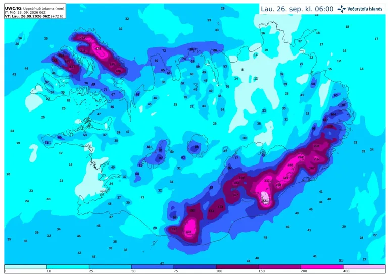
Accumulated precipitation over the next 72 hours, according to the IG weather model.