BETA
Precipitation and increased likelihood of landslide activity on Monday, 7 September
06.09.2026
Nýtt
Precipitation and increased likelihood of landslide activity on Monday, 7 September
On Sunday evening, a low-pressure system will move over the southeastern part of the country and then pass across the East Fjords on Monday, 7 September. The most precipitation is expected in the northern East Fjords, particularly south of Seyðisfjörður and around Mjóifjörður, where up to 110 mm of precipitation may fall within a 24-hour period.
The northern East Fjords have experienced rainfall during the past days, and groundwater levels have been rising. The rainfall forecasted for Monday will add to these conditions and increase the likelihood of rockfalls and debris flows in prone areas.
Heavy precipitation is not forecasted near the settlements according to the forecast there for landslides are not expected near the towns.
People are advised to exercise caution when travelling, avoid staying for long periods beneath gullies and steep slopes, and remain alert to conditions in their surroundings at all times.
The Icelandic Meteorological Office welcomes reports of landslides and avalanches. You can contact the office by phone at 522-6000 during switchboard opening hours (https://www.vedur.is/um-vi/hafa-samband/) or send information by email to skriduvakt@vedur.is.
When reporting an event, it is helpful to include:
- A photograph of the event (landslide, debris flow, or rockfall)
- The precise location
- The time when the event occurred, or when it was first observed
Landslides and other slope failures can also be reported using this form here.
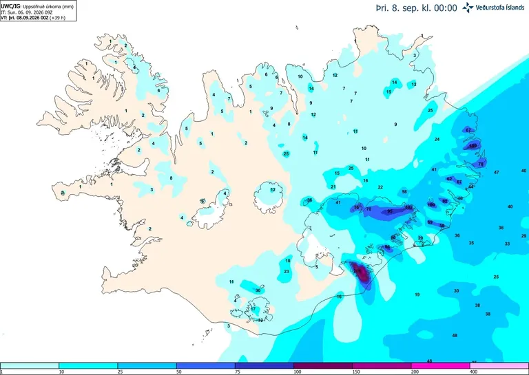
Accumulated precipiation until midnight on Monday