BETA
Significant rainfall forecast for northeast and east Iceland Saturday 8 August
08.08.2026
Significant rainfall forecast for northeast and east Iceland Saturday 8 August
Northern and northeasterly winds will prevail across Iceland today, Saturday 8 August, and weather forecasts indicate precipitation in the northern and eastern parts of the country. The heaviest precipitation is expected on the Flateyjarskagi peninsula and in the East Fjords. After midnight, precipitation is expected to decrease rapidly, and generally dry conditions are forecast for tomorrow.
Rain has affected northern and eastern Iceland during the past 24 hours, and forecasts indicate continued precipitation through the evening. According to the forecast, the heaviest precipitation is expected on the Flateyjarskagi peninsula and in the East Fjords.
Rockfall and small landslides beneath steep slopes and in road cuttings cannot be ruled out during the next 24 hours. No hazard to populated areas is currently expected.
The Icelandic Meteorological Office welcomes reports of mass movements and landslides. Information can be provided by calling +354 522 6000 during office hours (https://www.vedur.is/um-vi/hafa-samband/) or by sending an email to skriduvakt@vedur.is. If possible, please include a photograph of the landslide or rockfall, its precise location, and the time when the event occurred or was first observed.
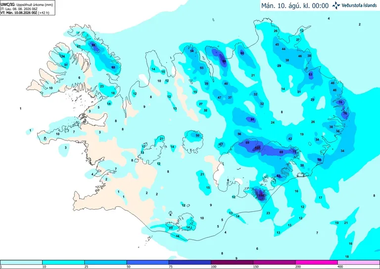
Accumulated precipitation for the next 36 hours according to the UWC/IG weather model.