BETA
Solar Eclipse Weather Forecast - Approximately 102 hours before the event
08.08.2026
Nýtt
Attention
Solar Eclipse Weather Forecast - Approximately 102 hours before the event
Latest forecasting model indicates that a low-pressure system will be located just south of Iceland on Wednesday before tracking northeastwards across the eastern part of the country. An associated frontal system is expected to move across Iceland from south to north, bringing mild conditions together with cloud and precipitation.
Compared with previous forecasts, the latest model guidance indicates less precipitation over western and northern Iceland. However, skies are still expected to remain mostly cloudy across much of the country, with cloud cover beginning to break up in western areas towards the evening.
Overall, this represents a positive trend compared with earlier forecasts. Nevertheless, several days remain until the eclipse, and the forecast could still improve further or shift back towards wetter and more overcast conditions.
National Forecast
Easterly to northeasterly winds of 3–10 m/s are expected. Cloudy skies with periods of rain are forecast in many parts of the country, while North and East Iceland are expected to remain mostly dry through much of the day. Temperatures are forecast to range from 8 to 18°C, with the coolest conditions along the northern and eastern coasts.
There is still some uncertainty regarding the timing of the frontal system and associated precipitation, although forecast confidence will continue to improve as Wednesday approaches.
Based on the current forecast, cloudy conditions are expected across much of Iceland, with precipitation affecting many areas. There is, however, an increasing likelihood that cloud cover will begin to break up later in the day once the front has moved through.
The available forecast models are now in relatively good agreement, suggesting increasing confidence in the overall weather scenario for Wednesday. At present, however, only coarser-resolution numerical models extend far enough into the forecast period. The high-resolution models used operationally for Iceland will begin producing forecasts for Wednesday during the Sunday evening model cycle. These will provide a much more detailed picture of cloud cover, cloud layers, precipitation type and precipitation intensity.
The forecast is therefore expected to become considerably clearer by tomorrow evening.
This forecast is updated twice daily and more frequently as the eclipse approaches.
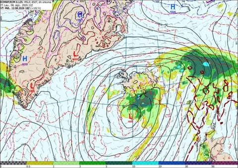
Forecast for 12 August at 18.00 UTC. Significant changes between forecast model runs remain possible at this lead time. Forecast charts should therefore be interpreted with appropriate caution.
Eclipse Path Forecast
Capital Region
Light and variable winds with mostly cloudy skies and occasional light precipitation. The likelihood of breaks developing in the cloud cover has increased, particularly during the evening.
Reykjanes Peninsula
Light northerly winds with cloudy skies and a chance of occasional light precipitation. Overcast conditions remain the most likely outcome, although there is now some indication that the cloud cover may break up to some extent.
Snæfellsnes Peninsula
Light and variable winds with dry conditions for most of the day. Some breaks in the cloud cover are possible, with the likelihood of clearer intervals increasing towards the evening.
Westfjords
Light northeasterly winds with dry weather expected. Conditions are likely to be considerably brighter over the southern Westfjords than in the northern part of the region. There is a reasonably good chance of breaks developing in the cloud cover, especially during the evening.