BETA
Solar eclipse weather outlook: Less precipitation in the latest forecasts
09.08.2026
Solar eclipse weather outlook: Less precipitation in the latest forecasts
Forecast issued at 11:00 on Sunday, 9 August.
The forecast covers the next 90 hours.
On Wednesday, a low-pressure system is expected to approach Iceland from the south. The latest weather model runs indicate that it will first approach the south-western corner of the country in the morning and remain there into the afternoon. It is then expected to move eastwards along the south coast during the evening.
Weather fronts and rain associated with the low will linger over southern Iceland. Another area of rain will also move northwards across the country during the morning and into the afternoon. The latest forecast indicates partly cloudy conditions with little rain in western Iceland during the afternoon, with a chance of local breaks in the cloud cover.
The main change from the previous forecast is that less rain is now expected in western and northern Iceland. Nevertheless, forecasts still indicate cloudy conditions across most of the country, with the cloud beginning to break up in the far west during the evening. This can be seen as a positive development, but there is still some time to go before the solar eclipse. Conditions could improve further, or the forecast could shift back towards more rain and overcast skies.
The forecast for the whole of Iceland on Wednesday is as follows:
Easterly and north-easterly winds of 3–10 m/s. Cloudy in many areas with intermittent rain, but dry in northern Iceland until later in the day. Partly cloudy with little rain in western areas during the afternoon. Temperatures of 8–18°C, coolest along the northern and eastern coasts.
There is still uncertainty regarding the precise timing of the weather fronts, rain and cloud cover, although this will gradually decrease as the event draws closer. The forecast models are now in fairly good agreement on the overall weather pattern. By this evening, the high-resolution forecast models for Iceland will extend through Wednesday evening. Forecasts from lower-resolution models will also continue to be assessed.
This forecast is updated twice a day, and more frequently as the event approaches.
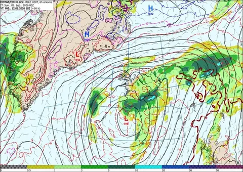
Map showing the position of a low-pressure system south of the Reykjanes Peninsula at 18:00 on Wednesday, 12 August. Rain is shown in green and yellow. Rain is expected across most of southern and eastern Iceland, while western Iceland will remain mostly dry. The low is forecast to move eastwards along the south coast as the evening progresses.
Changes in subsequent forecasts are likely, so forecast maps covering this far ahead should be treated with caution.
Weather outlook for areas where the total solar eclipse will be visible
Capital region
Light northerly or variable winds, cloudy with some light rain until later in the day. However, there is an increasing chance of breaks developing in the cloud cover, particularly during the evening.
Reykjanes Peninsula
Light northerly winds, cloudy with a chance of occasional light rain until later in the day. It will probably be overcast in the afternoon, although there is a slight chance of some breaks developing in the cloud cover, particularly during the evening.
Snæfellsnes Peninsula
Light north-easterly or variable winds and mostly dry after midday. Partly cloudy conditions are likely in the afternoon. At present, the cloud cover is expected to consist mainly of mid-level and high-level clouds, with few low clouds. Breaks in the cloud cover may become more frequent during the evening.
Westfjords
Generally light north-easterly winds and mostly dry after midday. Skies will probably be considerably clearer in the southern Westfjords than farther north, with a fairly good chance of breaks developing in the cloud cover during the afternoon. At present, any clouds are expected to be mainly mid-level and high-level, with few low clouds.
More information about cloud types, including photographs and their typical altitudes, is available in Icelandic at vedur.is, and in English at Cloudman and NOAA JetStream.